We are currently working on active navigation systems for autonomous or semi-autonomous vehicles based on the notion of “fields of safe travel” or “homotopy class”. The motivation behind this approach is the assumption that human drivers tend to operate vehicles within a field of safe travel rather than rigidly follow a specific path. In other words, human first makes decisions about avoidance strategy or desired goals, then tries to keep the vehicle within a field of safe travel corresponding to decision made. Based on this, we propose a framework that relies on identification and analysis of candidate fields, each of which can be interpreted to contain a path homotopy. Such navigation system tries to keep consistency of homotopy selection with human’s decision based on estimation of human’s intent or recommendation system. Once focus of planning and control comes down to each single field of safe travel, the system ensures safety while still allowing control freedom of human operator. The appropriate design of intervention time for this objective is achieve by measure of threat. The automated system ideally operates only during instances of significant threat: it should give a driver full control of the vehicle in “low threat” situations but apply appropriate levels of computer-controlled actuator effort during “high threat” situations. This approach preserves the freedom of motion of the human driver when he remains within the desirable navigable corridors and adjust its trajectory when its predicted future state falls out of these fields or when the lowest threat exceeds some threshold.
The three key points of the semi autonomous system are the following:
- Identification of fields of safe travel based on the sensory information related to the vehicle surroundings (nearby vehicles, pedestrians, road edges).
- Threat assessment or characterization of each field of safe travel.
- The question of when and how to intervene based on a threat in a way to achieve both of safety and respect of operator’s decision or preferences.
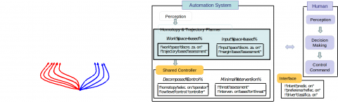
These three questions are related to each other and appropriate assessment of threat directly affects the performance of the system. In the current stage of the research, two different approaches are investigated: approach A. assessment based on optimal trajectory (workspace-based), approach B. assessment based on margin of control freedom (input space-based).
ApproachA assesses the threat of the best-case scenario. The cost of the optimal trajectory is the minimum required cost for ensuring safety, so the system intervenes only when even the optimal maneuver has a high cost for achieving safety. The problem comes down to a design of cost function and computationally efficient optimization. The cost function could be designed to accommodate severeness of maneuver such as longitudinal and lateral acceleration, sideslip angles although verification of the hypothesis is required. Given a cost function, this work is investigating a divide-and-conquer strategy of utilizing homotopy identification framework for efficient optimization in a sense that optimal trajectories for each of homotopy class should contain the global optimal trajectory.
In approach B, the threat to a vehicle is assumed to be proportional to the freedom of control afforded by a particular field. This implies that (for instance) drivers tend to prefer to navigate through regions that are wide and exhibit low curvature. To characterize threat in each candidate field, a set of feasible trajectories is evaluated rather than a single trajectory as in the first approach. For this purpose, a lattice is constructed via sampling either in input or state space. This sampling method enables identification of sets of feasible trajectories associated with each field; from which the metrics related to control freedom can be derived.